What is GPS?
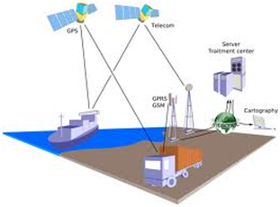
GPS or Global Positioning System is a satellite navigation system that furnishes location and time information in all climate conditions to the user. GPS is used for navigation in planes, ships, cars and trucks also. The system gives critical abilities to military and civilian users around the globe. GPS provides continuous real time, 3-dimensional positioning, navigation and timing worldwide.
How does GPS System Work?
The GPS system consists of three segments:
1) The space segment: the GPS satellites
2) The control system, operated by the U.S. military,
3) The user segment, which includes both military and civilian users and their GPS equipment.
Space Segment:
The space segment is the number of satellites in the constellation. It comprises of 29 satellites circling the earth every 12 hours at 12,000 miles in altitude. The function of the space segment is utilized to route/navigation signals and to store and retransmit the route/navigation message sent by the control segment. These transmissions are controlled by highly stable atomic clocks on the satellites. The GPS Space Segment is formed by a satellite constellation with enough satellites to ensure that the users will have, at least, 4 simultaneous satellites in view from any point at the Earth surface at any time.
 Control Segment:
The control segment comprises of a master control station and five monitor stations outfitted with atomic clocks that are spread around the globe. The five monitor stations monitor the GPS satellite signals and then send that qualified information to the master control station where abnormalities are revised and sent back to the GPS satellites through ground antennas. Control segment also referred as monitor station.
User Segment:
The user segment comprises of the GPS receiver, which receives the signals from the GPS satellites and determine how far away it is from each satellite. Mainly this segment is used for the U.S military, missile guidance systems, civilian applications for GPS in almost every field. Most of the civilian uses this from survey to transportation to natural resources and from there to agriculture purpose and mapping too.
How GPS Determines a Position:
The working/operation of Global positioning system is based on the ‘trilateration’ mathematical principle. The position is determined from the distance measurements to satellites. From the figure, the four satellites are used to determine the position of the receiver on the earth. The target location is confirmed by the 4th satellite. And three satellites are used to trace the location place. A fourth satellite is used to confirm the target location of each of those space vehicles. Global positioning system consists of satellite, control station and monitor station and receiver. The GPS receiver takes the information from the satellite and uses the method of triangulation to determine a user’s exact position.

No comments:
Post a Comment